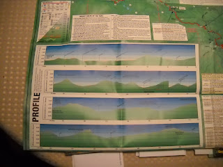
The Tour Divide follows the Adventure Cycling Association's Great Divide Mountain Bike Route from Banff, Alberta to Antelope Wells, New Mexico. Years of work went into researching and mapping the route and the Adventure Cycling Maps are essential guides to the trail. The Association works to constantly keep these maps up to date, publishing revised maps as needed and providing addenda of info that has changed since the last map printing. My vintage 2005 maps from the last time I raced the Divide by now had dozens of addenda items, so I splurged and got myself the most recent set of maps. In theory, someone could navigate the entire route entirely by GPS and the Adventure Cycling folks have all the GPX files available for download on their site, but the paper maps are packed with much more handy info than can be captured in mere coordinates.

The double-sided Adventure Cycling maps are corridor maps, they focus on the route. While they provide a wealth of information about the route, terrain and services on or close to the trail, with the exception of a small (4" x 4") index map the maps don't show much of the world beyond the route. If you are planning on venturing off route, you'll need general maps.
The maps are very well designed to keep you on route and every square inch of them is packed with useful data. Even the smallest towns along the route are listed, along with the services you'll find there. Campgrounds are listed as are motels, bike shops, libraries, grocery stores and service stations. The maps also include a bit of history and weather data. Also included are the handy and sometimes depressing elevation profiles.

Turn by turn directions are designed to keep you on course, with mile and kilometer designations and a bit of description. At times the description is cautionary ("start climbing a virtual wall") while other times it celebrates the terrain ("entering magnificent country offering long-range views").
In addition to the maps, my friend Dawn made sure that I have the latest edition of Michael McCoy's book Cycling the Great Divide. This book narrates the US portion of the trail as a sixty-two day trip. When I raced the Divide back in 2005, I used the first edition of this book for research. Of course, since I was racing, I compressed McCoy's schedule by a factor of three. I took the maps with me and left the book home with Christine. On my nightly call-ins I'd often ask her "what day am I in the book?"
The maps are not the terrain, but they are the stuff of dreams and the details we need to make the proper turns on a twisty trail. I'm a proud member of the Adventure Cycling Association. There the folks that make these adventures possible.
Keep 'em rolling,
Kent


4 comments:
I've used the Adventure Cycling maps of the "Pacific Coast" route through Washington and Oregon, and thought they were fantastic. I'm also planning on using their "Northern Tier" maps to plan a trip across Washington from west to east.
Good luck with everything during the race, and enjoy those maps!
Thanks for the nice post on the Great Divide Mountain Bike Route!
Winona
Media director, Adventure Cycling Association
www.AdventureCycling.org
You might consider reading Marty Basch's Twenty-Nine Hills. It's a travelogue about a couple who rode the divide just for fun (not racing); it's more entertaining than technical. I enjoyed it.
Speaking of terrain I'm hoping you will post something some day about your hill climbing technique. I have a singlespeed mtb and I find sometimes you just have to grunt it out. I wonder if you've come up with some ways to finess the hills, many of which are surely not easy rises on the Divide.
Post a Comment